If you’ve ever walked out of the woods thinking, I’m doing everything right, so why doesn’t this feel better? You’re not alone. You’ve shot does. You’ve passed young bucks. You’ve planted food plots and tried to be patient. And yet the rut still feels short, daylight movement feels thin, and the bucks you’re hoping for never quite show up. One of the most common reasons is also one of the least clearly understood: your buck-to-doe ratio.
At its simplest, the buck-to-doe ratio is just how many bucks exist on a property compared to does. But that simple number carries a lot of weight. It influences how deer move, how the rut unfolds, and how exciting—or dull—the season feels from the stand. Wildlife biologist Dr. Bronson Strickland put it plainly during a recent episode of the Huntin’ Land podcast. An imbalanced ratio won’t stop reproduction, but it will change behavior in ways hunters notice.
“It’s really not going to impact the population whatsoever,” Strickland said. “If you have an imbalanced ratio, there’s still going to be productivity there, and fawns are going to be born. But you’re going to have a more exciting hunting environment if the sex ratio is more even.” When does far outnumber bucks, he explained, mature bucks don’t have to move much to find a receptive doe. That means less chasing, less daylight activity, and a rut that feels muted. “When you start balancing that sex ratio out, bucks are going to have to search for does, and it just makes the hunt more fun,” a dynamic often missing on properties where doe harvest has lagged behind buck harvest for years.
How Hunters Have Traditionally Estimated Buck-to-Doe Ratios
Most hunters try to figure out their ratio using trail cameras, observation logs, and harvest data. Cameras go over feeders or food plots. Deer get counted. Patterns get guessed at. On top of that, hunters mentally track what they see from the stand across a season and try to make sense of it all.
The problem is that none of those methods show the full picture. Trail cameras only capture what walks directly in front of the lens, at one specific spot, at one specific moment. A deer can pass ten feet behind a camera, circle downwind of a feeder, or avoid that location entirely and never trigger a single photo. The data feels precise, but it’s often incomplete. What you’re really seeing is a narrow slice of the herd, not the herd itself.
Observation logs have their own limitations. Deer sightings change with weather, acorn crops, hunting pressure, and time of day. Seeing ten does one afternoon and none the next doesn’t necessarily mean the population shifted. It usually means the deer did. Harvest data helps, but it’s slow feedback. If you decide to shoot one doe per 50 acres and wait a year or two to see whether buck quality improves, you’re committing serious time and effort before knowing whether you were even close. That delay is a big reason hunters burn out on quality deer management. You’re working hard without knowing if the plan is right.
How Aerial Surveys Change the Equation
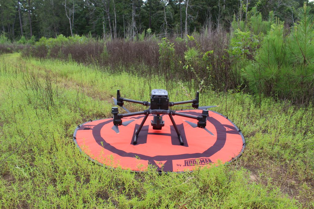
That uncertainty is exactly where aerial surveys have changed the game. Instead of relying on indirect clues, thermal-equipped drones allow surveyors to count deer that are physically on the ground during a very tight window of time. According to Justin Ballard of Paragon Aerial Solutions, the biggest advantage is certainty. “With the thermal technology that’s out now, when you’re flying, there’s either a heat signature there or there’s not,” Ballard said. “It’s undeniable. You’re not guessing if a deer is there.”
To make that certainty meaningful across large properties, Paragon flies multiple drones at once. Each pilot covers a specific section, and only that section. “We’re flying three, four, sometimes five drones at a time, depending on the size of the property,” Ballard said. “Each pilot has a specific area that they fly, and they only cover that area. That way we’re not double-counting deer, and we’re not missing anything.” By covering ground quickly—roughly a hundred acres per hour per drone—the survey happens fast enough that deer don’t have time to drift from one section into another and get counted twice.
That speed matters. Trying to fly a large property with a single drone would introduce the same problems hunters already face with cameras. “A deer could walk a mile an hour,” Ballard said, “and by the time you finished one end of the property and got to the other, that same deer could be somewhere completely different.” Flying multiple drones compresses the survey into a short, controlled snapshot of reality instead of a stretched-out estimate.
More Than a Headcount
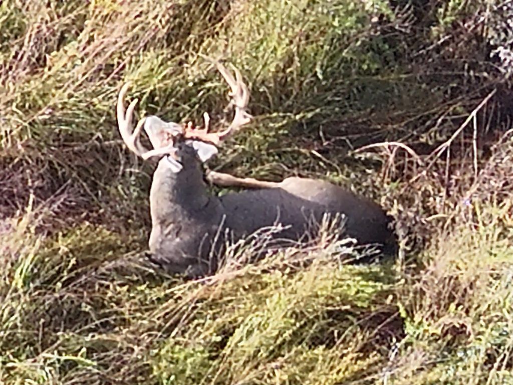
The real value of aerial surveys isn’t just knowing how many deer are out there. It’s understanding herd structure. Paragon typically flies during the daytime on overcast days, which allows pilots to switch between thermal and standard cameras to identify sex and even antler points. “During the day, you can tell the difference between a six-point and a seven-point,” Ballard said. “You can really get the details and have some really good data.” That clarity lets landowners see exactly how many bucks and does are present on a given day, instead of inferring ratios from partial information.
Just as important, the data often challenges assumptions. “People always think they have more deer than what they have,” Ballard said, especially on unfenced properties. In many cases, landowners are surprised to learn their buck-to-doe ratio is far more skewed than they believed, or that deer are heavily using parts of the property they rarely hunt. That kind of reality check is what turns aerial surveys from an interesting tool into a practical management decision.
Ballard shared a clear example. “We flew a place last year, about 2,600 acres, and when we first went in there they had one buck for every 3.3 does,” he said. “That was the real number, not an estimate.” With that information, the landowner made a deliberate decision to focus hard on doe harvest. “He wanted to get to one buck for every two does,” Ballard said. “So he went and killed a lot of does that year.”
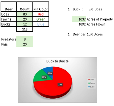
When Paragon returned the following season, the results were clear. “We flew it this year, and based on the count we gave him, that’s exactly what he had,” Ballard said. “One buck for every two does, which is exactly what he was aiming for.” The value wasn’t just in the harvest, but in the confidence. “He knew where he started, he made a plan, and then we came back and confirmed that it worked.”
Turning Buck-to-Doe Data Into Action
Knowing your true buck-to-doe ratio gives you confidence to act. Instead of guessing how many does you should shoot, you’re making decisions based on real numbers. It also helps set expectations. If you intentionally reduce deer density, you may see fewer deer per hunt for a year or two. Without data, that can feel like failure. With data, it looks like progress.
For hunters managing smaller properties, the value often extends beyond the fence line. Accurate numbers open conversations with neighbors about cooperative management. A survey report carries more weight than a handful of trail-camera photos because it comes from an objective source. Deer don’t respect property boundaries, and meaningful improvements usually happen when neighbors work from the same information.
Determining your buck-to-doe ratio doesn’t have to be a guessing game anymore. Traditional methods still have a place, especially when paired with harvest records and observation. But aerial surveys offer a level of clarity that simply wasn’t available to most hunters until recently. When you know what’s actually on the ground, you can set realistic goals, shoot does with purpose, and stick with a plan long enough to see real results.