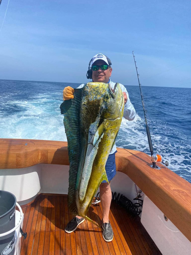
For offshore anglers serious about targeting dolphin (mahi-mahi), satellite fishing maps have become one of the best tools available. Mahi-mahi are an incredible fish species, growing as fast as 3 inches per week and reaching 20-30 pounds in their first year. Known for their vibrant colors and rapid growth, mahi-mahi are a prized catch. The current world record for this species, caught off the coast of Costa Rica in 1976, weighed an impressive 87 pounds.
While traditional methods—such as searching for birds, weed lines, and floating debris—remain effective, satellite technology has introduced a new level of preparedness for targeting these fish. By offering more fishing time and better insights into prime fishing spots, satellite maps increase catch rates and save time. Whether fishing in the Gulf of Mexico or along the East Coast, understanding how to interpret satellite data, such as that from Hilton’s Realtime-Navigator, can mean the difference between an empty cooler and a successful day on the water.
What Are Satellite Fishing Maps?
Satellite fishing maps are a technological tool that provides real-time or near-real-time data on ocean conditions. These maps display sea surface temperature (SST), chlorophyll levels, current patterns, and even plankton concentrations. Each element helps anglers locate conditions favorable for pelagic species like mahi-mahi. Unlike traditional fishing methods relying on word of mouth or visual cues, satellite maps, like those from Hilton’s Realtime-Navigator, offer a detailed view of subsurface activity, allowing anglers to make informed decisions before leaving the dock.
Hilton’s SAT2NAV System enhances satellite fishing maps by integrating real-time ocean data with modern navigation technology. This system allows anglers to download and display dynamic charts directly on their marine electronic devices, including Garmin, Furuno, and Raymarine chart plotters. These features are accessible even outside cell range, making the system invaluable for offshore fishing.
Users can overlay these charts with other data, such as bathymetry or instrumentation, providing a comprehensive view of fishing conditions. The SAT2NAV system connects via Wi-Fi to Hilton’s server, enabling seamless updates and customization of maps before setting sail. This innovation allows anglers to identify productive fishing zones efficiently, saving time and enhancing catch potential while reducing reliance on traditional methods like visual cues or hearsay.
How Mahi-Mahi Behavior Relates to Satellite Data
To understand how satellite maps aid in finding mahi-mahi, it helps to consider their behavior. Mahi-mahi are pelagic predators that follow temperature breaks, current edges, and areas with abundant forage. These fish often gather near weed lines, floating debris, fish aggregating devices (FADs), and waters that offer ideal feeding and breeding conditions. Being highly migratory, mahi-mahi cover long distances in search of feeding opportunities and tend to follow temperature breaks where warm and cooler waters meet, which often concentrates baitfish. Hilton’s Realtime-Navigator enables anglers to pinpoint these temperature breaks and other conditions critical for locating active mahi-mahi.

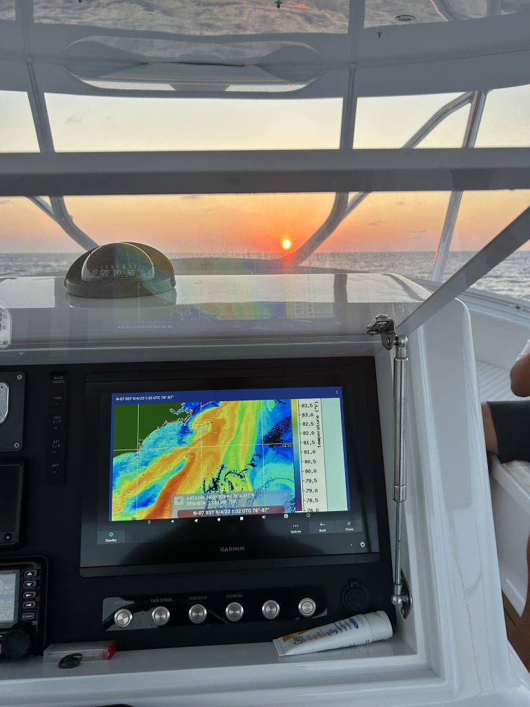
Reading Sea Surface Temperature (SST) Maps
Sea surface temperature (SST) maps are essential when targeting dolphin with satellite fishing maps. These maps display water surface temperatures, helping anglers locate temperature breaks that mahi-mahi are known to prefer. Generally, mahi-mahi thrive in water temperatures ranging from 75°F to 85°F, although they can tolerate slight variations if other factors, like bait availability, are favorable. A temperature “break,” where two different water masses converge, is where baitfish and mahi-mahi often gather. Hilton’s Realtime-Navigator offers accurate SST maps, allowing anglers to quickly identify these breaks—often just a few degrees apart—and head to areas with the highest chance of action.
Chlorophyll Maps: Finding the Food Chain
Chlorophyll maps are another essential tool for targeting mahi-mahi. Levels of chlorophyll levels indicate areas rich in plankton, where the food chain begins. High chlorophyll concentrations attract baitfish, and where there are baitfish, predators like mahi-mahi are often close by. However, too much chlorophyll can signal murky water, which mahi-mahi avoid. These fish prefer clean, blue-green waters with moderate chlorophyll levels. Hilton’s Realtime-Navigator provides detailed chlorophyll maps, helping anglers locate optimal areas with clean, nutrient-rich water while avoiding less desirable zones.
Practical Tips for Using Satellite Maps While Fishing
Having access to a tool like Hilton’s Realtime-Navigator is one thing; knowing how to use it effectively is another. Here are a few practical tips for maximizing this technology:
- Combine SST and Chlorophyll Data: Use both SST and chlorophyll maps together for the best results. Look for a temperature break with moderate chlorophyll levels—this is often an ideal spot for mahi-mahi.
- Check Current Patterns: Review current maps as well. Mahi-mahi tend to gather along current edges, which often accumulate weed lines and floating debris, providing structure and food.
- Be Timely: Satellite maps are most useful when the data is current. Offshore conditions change quickly, so ensure you’re working with the latest information from Hilton’s Realtime-Navigator.
- Adapt on the Fly: Bring a tablet or smartphone to access Hilton’s Realtime-Navigator in real time while on the water. If conditions change, you can adjust your strategy immediately.
- Use Visual Cues: Satellite maps help narrow down key areas, but always keep an eye out for visual cues like birds, weed lines, or floating debris. Mahi-mahi often gather near these features, forming mini-ecosystems that can be easy to overlook without visual confirmation.
Conclusion
Satellite fishing maps, particularly those offered by Hilton’s Realtime-Navigator, have transformed how anglers target pelagic species like mahi-mahi. By leveraging SST and chlorophyll data and understanding how this information relates to fish behavior, anglers can greatly improve their chances of locating ideal conditions for catching these thrilling gamefish. Not only does this technology save time and fuel, but it also makes each fishing trip more productive and enjoyable.
So, the next time you head offshore, don’t forget to consult Hilton’s Realtime-Navigator. This technology might just turn an ordinary fishing day into an unforgettable adventure.