As most offshore fishermen know, water conditions play a crucial role in successful fishing. That’s why Thomas Hilton founded Realtime Navigator in 2004 and launched Sat2Nav in 2022. Both tools offer valuable chartplotter features that benefit deep-sea fishermen, providing a significant edge in the water.
What is Sat2Nav?
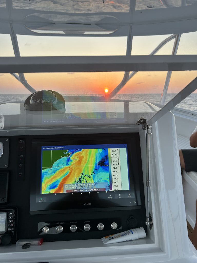
Sat2Nav connects to devices such as a Garmin chartplotter, a Furuno chartplotter, a Raymarine chartplotter, or similar units, enhancing your plotter’s capabilities. It essentially amplifies what your chart plotter can do, transforming it into a more powerful tool for navigation and fishing.
“The Sat2Nav is a game changer,” Hilton said. “It’s a full-fledged computer. You can do things with a chartplotter that none of the chartplotter companies can offer on their own.”
For instance, Sat2Nav allows you to connect directly to Hilton’s website on-screen and update your device with the latest charts. “I designed it for StarLink, Elon Musk’s array of low-orbit satellites, which provides high-speed Wi-Fi,” Hilton explained. “It’s a game changer.”
Sat2Nav comes with a series of apps, including access to the internet, letting you browse websites like ESPN, Netflix, and WhatsApp. Most importantly, you can seamlessly switch between accessing the internet for chart updates and navigating the waters. These updated charts are automatically loaded into your device, enabling you to chart routes to critical areas like color changes, temperature breaks, and other essential waypoints.

Collaborating with Competitors
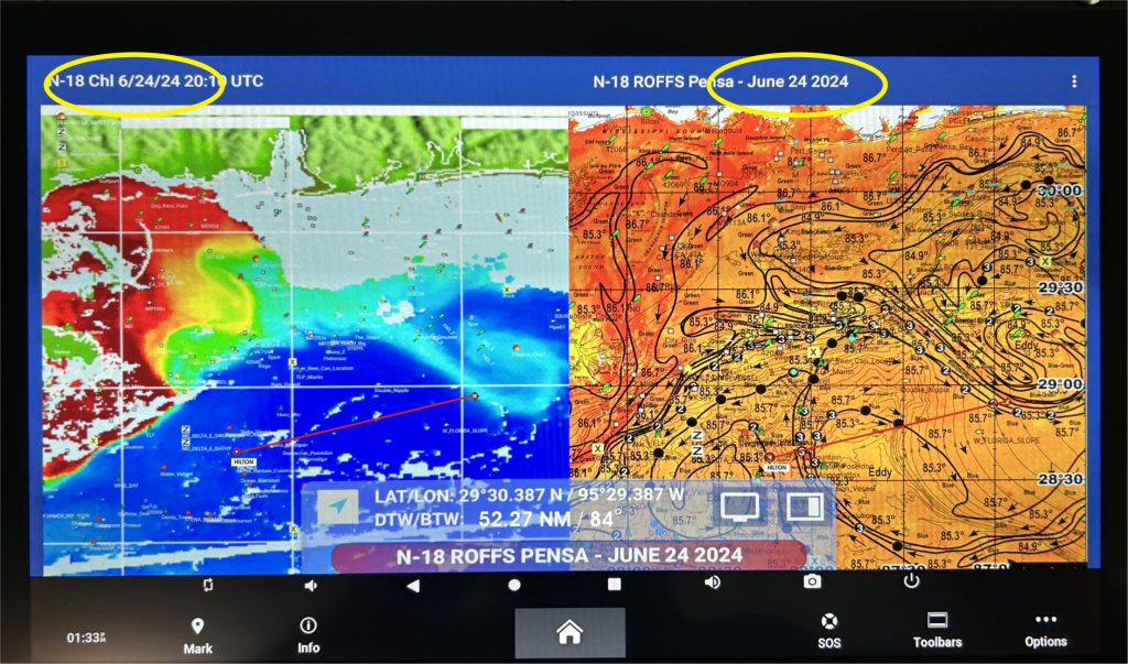
“In the spring of this year, we collaborated with one of our competitors, Roffs, in the Gulf of Mexico,” Hilton said. “We share many crossover customers, so we thought it would be beneficial for them to view both types of imagery side by side on their chart plotters. Now, with the Sat2Nav split screen, you can view your vessel simultaneously with two different types of charts.”
Many variables influence why fish might be in one spot today and somewhere else tomorrow. Hilton emphasized the importance of tracking as many of these factors as possible to increase the odds of success. “It helps you see the full picture while you’re out there, and that boosts your chances of finding fish. The key is to locate areas where you have the most overlap in favorable conditions.”
Sat2Nav Increases Efficiency and Success
With Sat2Nav, fishermen now have critical data that tells them where to go and where to avoid, based on real-time information. Time on the water is limited, and with the rising costs of operating a fishing vessel, efficiency is essential.
“Our units help reduce costs while increasing the odds of success,” Hilton said. “You can navigate with charts that are only hours old. As soon as they’re available from the satellite, they’re accessible to you.”
One particularly useful feature of Sat2Nav is the ability to navigate on the same imagery from different times. Hilton explained, “Let’s say you’re using the latest sea surface temperature shot to create a route to a temp break. With the split screen, you can mirror that route and see it relative to water color, currents, and other factors.”
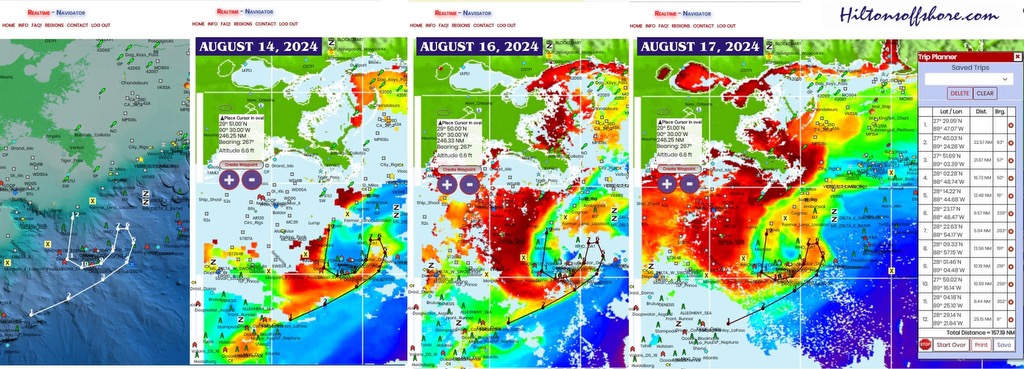
Historical data is also valuable. By pulling shots from four, six, or even eight hours earlier, you can track the movement of dynamic structures, calculate their speed, and determine when they’ll reach your area, allowing you to chart your course accordingly.
“The days of heading offshore and hoping to stumble upon fish are over,” Hilton said. “With Sat2Nav, you’ll know exactly where you’re going before you even leave the dock. That might be 200 to 250 miles away, but you’ll have a clear destination.”
Save Time and Fuel
By using Sat2Nav, fishermen save time and fuel. The cost of a subscription is easily justified by the savings and increased efficiency. “If you spend $260 per year on Sat2Nav, by the end of the year, you’ll have saved far more than that on fuel alone,” Hilton added. “You’re not wasting time or resources fishing in unproductive waters.”
For fishing guides, this technology can lead to even greater success. Better results translate to happier clients, bigger tips, and higher-paying customers, ultimately boosting annual revenue.
“We’re blazing a new trail,” Hilton said. “We’re the first to combine internet and navigation capabilities in one package. We pioneered online mapping 20 years ago with Realtime Navigator, and we’re continually working to stay ahead of the technological curve. By collaborating with competitors, we’re delivering a superior product for our customers.”
Real-Life Example of Sat2Nav in Action
Hilton shared a recent example of how Sat2Nav’s technology can improve fishing success. “A few days ago, a counterclockwise current was coming out of the Mississippi Delta,” Hilton said. “Based on chlorophyll shots—measuring concentrations of phytoplankton that make the water greener—we observed a pocket of cobalt blue water encircled by dirty river water.”
The mix of different water colors—dirty, fresh water indicated by red, orange, and yellow; green for more turbulent waters; blue-green for blended areas; and dark blue for clear, deep water—created an ideal fishing situation. “The pocket of blue water was surrounded by various structures like drill sites,” Hilton explained. “When currents form these pockets, it’s like shooting fish in a barrel. The fish won’t leave that area.”
By analyzing how these currents change over time, fishermen can stay on top of evolving conditions and adjust their fishing strategy accordingly. For example, in Hilton’s scenario, the western edge of the pocket moved westward, while the southern edge remained stable—key information for maintaining a successful fishing trip.
Without a doubt, the ability to compare multiple charts or time frames significantly enhances offshore fishing.
Giving Back to the Fishing Community
While Hilton’s services offer significant advantages to fishermen, he’s also committed to supporting marine ecosystems. With the removal of oil platforms leaving vacancies in the Gulf, Hilton sees the need to create new essential fish habitats.
“Someone once told me I’d go to fish hell for directing so many people to fishing spots,” Hilton joked. “So, I got involved in creating artificial reefs about 15 years ago. We developed a new process for producing reefs and have deployed over 5,000 in Texas state waters. Now, people can fish for snapper, king mackerel, and more year-round. It’s my way of giving back to the fishery.