The biggest problem in offshore fishing trips most days is, as a salty old skipper once told me, “there’s an awful lot of places where they ain’t.”
Finding that elusive needle in the haystack would look easy compared to finding a blue marlin on some trips. The oceans are huge and the fish are scarce, even where they’re in relative abundance. This is where an excellent offshore fishing report can be invaluable.
How do you find them?
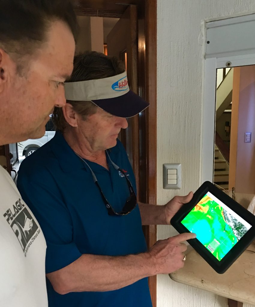
Thomas Hilton, founder of Hilton’s Realtime Navigator in Arcola, TX is now providing a digital pathway that’s being followed by an increasing number of top skippers. Hilton, who’s been at it for over 17 years and has done plenty of Texas offshore fishing, takes advantage of a wide variety of satellite feeds to map conditions on coastal seas and provide offshore skippers with the clues they need to find billfish, tuna, wahoo and mahi maki consistently.
His system makes use of the layering capability of satellite photos to record various parameters offshore.
“We can show the angler the most recent up-wellings and down-wellings, water temperatures, chlorophyll levels, water clarity, currents and wind direction, salinity levels, bottom structure, oil and gas rigs and the actual daily movement of drill ships and other more-or-less permanent structure out there,” Hilton said. “The baitfish locations relate to all these conditions, and where the bait is, the gamefish will usually be.”
Upwellings, water flowing upward from the depths, bring nutrients and food from the lowest levels to the surface and attract gamefish. Ironically, they are LOWER than mean sea level, as indicated on Hilton’s readouts. Downwellings, where surface water sinks toward bottom, have little nutrients or bait and are poor fishing areas. These upwellings and downwellings can vary from mean sea level by as much as 16 inches at times, Hilton noted.

Chlorophyll, the base of the food chain, is also critical, he says.
“You can be in beautiful cobalt-blue water with plenty of current and everything looks just right and yet there’s not fish or bait anywhere because there’s no nutrient to start that food chain,” Hilton pointed out. “Our system can put you in areas where the food chain is strong, and that’s where the gamefish will be most of the time, often right where that green water, loaded with chlorophyll and food, meets deep blue.”
He also noted that while knowing the sea surface parameters often give anglers a tremendous advantage on offshore fishing trips, knowing the daily position of moveable structures like drillships can ace even that knowledge.
“We invest a lot of money in getting the daily position of all these movable structures and plug it into our system with exact lat/lon data. On many days, even when parameters are not the best, there will be lots of bait and so plenty of fish right on those structures. You can catch some big billfish in green water where you wouldn’t expect to see them if there’s lots of bait.”
He said that bottom structure can also play heavily in where action will be best. In fact, wahoo and big kings particularly relate to bottom structure in 100 to 200 feet.
“Find an area where you’ve got a seamount or a ridge and several of the other parameters are right, maybe a current flow bumping up against that obstruction or a current seam running along it and you’re likely to have a hotspot as long as those conditions last,” Hilton said.

According to Hilton, not only does the system improve catches, it often allows skippers to greatly reduce their running time searching for spots where the bite is happening. This can reduce fuel use dramatically and make the best use of the available time, critical in high-dollar offshore tournaments.
“Our service costs between $200 and $1500 a year depending on how many features you want, and the angler can save more than that in fuel savings in just one trip with a big twin-engine sportfisher,” Hilton said.. “To say nothing of the advantage it gives you in competition.”
And now, he has come up with a new angle that allows anglers to project where fish will be today or tomorrow depending on where they were last week, last month or last year. It’s called the H.E.L.P. system, Hilton’s Electronic Logbook Program. It’s a sort of reverse engineering to figure out where the fish are going to be for the next trip.
Hilton calls it “fishing with the rear-view mirror.”
“We can tell where to go tomorrow based on last week in many situations,” he said. “We found that a lot of the top skippers keep a very careful paper logbook of where and when they catch fish so that they can look back and see clues of where the action might be on their next trip.
“So we now offer that digitally, for those who keep a record of their catches on our system, so that they can bring up the locations of past catches and the exact conditions at that spot at that time.”

They can look for areas that have the same conditions as those that produced the catch. That area may be 30 or 50 miles away, but at the same time of year, it’s a pretty good bet it’s going to be productive again if it has the same set of conditions,” Hilton explained
The program also keeps track of where movable structure was placed in the past, as well as currently. That means anglers can quickly note if a drill-ship or other structure was located on spots that produced in the past, thus tipping the scales over natural conditions. Last but not least, it provides major/minor feeding times for that lat/lon position on that day.
“Things are always changing offshore and it’s a dynamic system,” Hilton said. “But if you keep an eye on conditions through our system and project where all the conditions are going to be right on the day of your trip, it puts you in the right zip code with the fish much more often than otherwise.”
Hilton admitted that all this data can appear to be a bit overwhelming for new users, but most skippers quickly become adept.
“Once you’ve got the basics, you just download your information to your cell phone or iPad in the morning and go fishing,you don’t have to stay in cell phone range to use your plan for a one-day trip because the conditions are usually going to be stable for some time unless you get a big weather system coming in,” Hilton said.
Captain Patrick Ivie of the Breathe Easy, a 68-foot Viking owned by Matt McDonald in Orange Beach, AL was the winning captain in the 2016 Gulf Coast Triple Crown Championship and many other competitions since. He said he likes the fact that anytime, if he is offshore fishing Destin, Florida for example, and he has questions about Hilton’s programs or what he’s seeing on the screen he can pick up the phone and give Thomas a call, day or night.
“The information is updated so often that it really helps us out on offshore fishing trips,” Ivie said. “I like that the overlays can be put down individually, so you can see exactly what you want. You match your fuel burn and speed to make your day most efficient. Things change fast out there, just overnight, the current can be very different and I get that right away in the morning real-time so I’m ready to get it done.”
And, Ivie said, the whole system is relatively easy to master.
“There is a learning curve to best utilize the site, but it is not rocket science – once you understand the basics, it’s like riding a bike.”
Captain Myles Colley of Born2Run, a 72 Viking running out of Pensacola, FL is another major tournament winning captain who said he uses Hilton’s almost exclusively to keep tabs on offshore fishing trip conditions, even when he’s not fishing, to stay aware of trends and developing patterns he can use when on the water.
“I like that even if there are clouds out there over the water so there are no good images the day before my trip, I can put together the preceding 3 or 7 days and see what’s happening and project what to expect today,” Colley said.
“I also like the weather tab, which shows wind direction and waves on the area we like, so we know exactly what to expect when we get out there. In winter we look for the warm water, and in summer we look for all the other elements Hiltons Offshore provides—and 90 percent of the time we look for those conditions close to one of the offshore structures, which the system also gives us.”
Colley said that before offshore fishing trips and big tournaments he and other skippers used to hire a private plane to fly over the fishing area and look for weedlines, slicks and fish, but now, that’s no longer necessary.
“Hilton’s is the most valuable tool we have other than quality bait,” Colley said. “It’s essential to the way we fish now.”
To learn more about Hilton’s Realtime Navigator, visit their site https://realtime-navigator.com.