Thomas Hilton’s Realtime Navigator, a service that collects satellite imagery and makes things like SST charts and salinity maps easily understandable and accessible to sportfishermen and offshore mariners, has been in business some 18 years this spring, and the service has helped thousands of users to great fishing. It’s now a staple of many top offshore fishing captains and tournament winners who use it to plot their strategy for finding fish on a regular basis.
It’s also been a huge plus in decreased fuel bills and wear and tear on marine engines—skippers can pull up the parameters they know will lead them to fish on Hilton’s online system via connected PC, laptop, tablet or smartphone and chart a course directly to the prime waters. There are no long hours of running and looking—and no longer a reason to charter a small plane prior to a big tournament and fly out to the shelf to scope out prime fishing areas.
Recent upgrades have made the service even more useful according to originator and CEO Thomas Hilton.
“Captains now are able to actually see their boat’s position relative to the latest imageries while out on their spots,” Hilton said. “So, you can not only plan your trip in advance, with a satellite link you can see where you are in relation to that temperature break or current edge in real time.”
Thomas began monitoring five new NOAA satellites last year for improved sst chart readings, as well.
What Should Anglers Look For In SST Charts?
A temperature break is one of the biggest features, particularly late fall through early spring when chilly waters in the northern gulf keep fish many miles offshore until a swirl of the warm Gulf Loop or offshooting eddies brings them closer.
“A break of half a degree or even less can sometimes indicate a likely spot, but of course a 4-degree break with a clear edge is a buffet line for the pelagics so that’s ideal, but not very common.” Hilton noted.

If you see a nice temperature break near some sort of offshore structure on your sst charts, the odds go up even more, says Hilton—and all the structures in the Gulf, from fixed platforms to moveable rigs to Fish Attracting Devices (FAD’s) are marked on Hilton’s charts.
“The FADs are always a good place to start when the water color is good there,” Hilton pointed out “And they’re close enough for a day trip for a fast boat.”
Hilton says the ideal situation to see is when all the parameters point to the right conditions to hold bait, which will usually attract offshore gamefish.
“If you see the right temperature on your sst charts, the right water color, a good current movement and it’s flowing around structure, that’s going to be a very high percentage spot,” Hilton explained. “Structure holds bait, so when you find the right temperature and water color around structure, that’s a spot you’re very likely to catch fish,”
“Even where there’s no surface structure, if you get two or three of the prime conditions, maybe low chlorophyll, an upwelling and current flowing over the continental shelf or a sea mount, that’s also going to be a likely spot to find fish,” he added. “And of course, weedlines that form on the edges of color changes or on the shelf or near a structure, that all adds up to fish.”
The Currency of SST Charts and Offshore Data
“Sea surface shots come in at 35 to 40 per day from NOAA satellites, so that’s very current, within two to three hours,” Hilton stated. “Chlorophyll readings, on the other hand, are from the day before, but you can look at several days prior to see the likely trend for your fishing days. Some services claim to provide “real-time” data to download offshore – this is a misnomer as there is no such thing as “real-time” – there is always a delay of a few hours to several hours”.
“You can also get Hilton’s while you are offshore if you have a satcom/WIFI interface—hook it up to your iPad and you can get updates anytime,” he said. “You can set this up for less than $3,000. You don’t need it for day trips but if you’re out there for 3 days or a week, those updates will be a huge help.”
Users can save their data to the systems and access it when offshore without the need for a satellite link. The data won’t be “live”, but conditions usually change slowly offshore so the downloads are very useful.
“Our system lets you monitor the tendency of movement of the currents and temperature breaks in the days leading up to your trip so you can project where they will be on your fishing days and take a direct route to intercept them—that alone can be a huge fuel savings if you’re running a hundred miles out,” Hilton said. “You will also be able to overlay our data on your boat’s positioning screens and mark the spots that look fishy as well as the spots where you actually catch fish.”

While the system is no guarantee you’ll be on the fish, it does mean you’re unlikely to spend hours plowing through lifeless seas where bait is absent and other conditions don’t suit big game fish—it maximizes your time on the water.
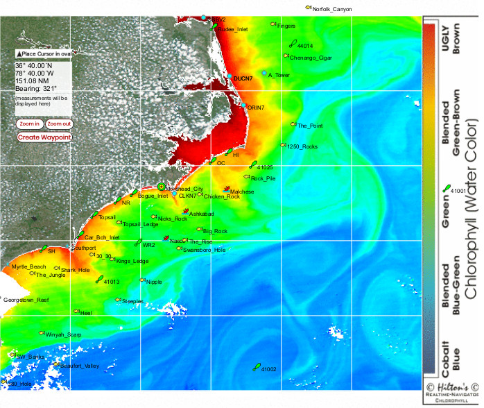
Moving the cursor when it’s linked to the Nav Tool gives you the exact coordinates of a spot down to a thousandth of a minute of any location, a huge plus for precise location of surface structures.
Parameters like the temperature range you’re interested in can be pinpointed and the edges of the various temperatures brightened and colorized to make it very clear where those edges are located.
You can then save that sst map for future reference, with your customized colors in place.
Down the left side of the screen are choices of data you want to review:
Currents, Salinity, and Weather Radar
Chlorophyll
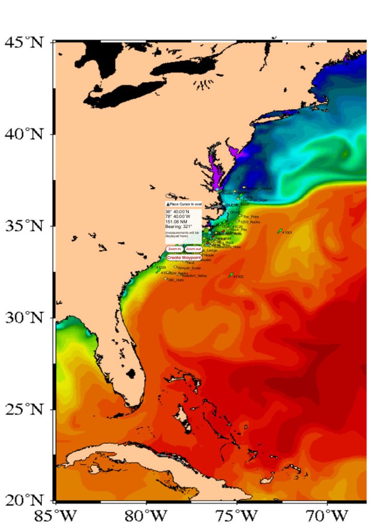
Realtime Navigator indicates chlorophyll by “hot” colors orange and yellow inshore where there’s lots of runoff, resulting in high chlorophyll load and turbidity, shading to green as the nutrient falls out farther offshore, and then to blue, which indicates the cobalt blue clarity of offshore waters.
Altimetry
Altimetry is a curious phenomenon also measured by the satellites and easily reviewed in Hilton’s Realtime system. It measures an average sea surface height, and then indicates areas that are either higher or lower than that level.
Oddly, those that are lower indicate upwellings of cold, nutrient-rich water from the sea bottom, and these are often attractive to the planktonic base of the food chain, luring bait as well as gamefish. Hilton says the sea surface over a strong upwelling may be as much as 10 inches lower than the mean sea surface level.
Warm-core eddies, on the other hand, may be 15 to 20 inches higher than the mean sea level. While the interior of these eddies are usually like fishing the Dead Sea, the edges can be highly productive, especially in the cooler months when gamefish are looking for warmer water.
Salinity
Hilton’s just launched a new “cloud-free” salinity imagery which also allows one to tweak the readings to sharpen the imagery – no other service provides this ability. There are many variables as to why fish are on a spot one day and not the next, and salinity is an important one. It can be important for determining where to fish whether you are fishing for king mackerel or yellowfin tuna.
Areas that might normally produce very good king-fishing, such as around a nearshore rig, can be turned off after a big outflow from a bay or river, and checking for where the edge of the saltier water is located can make a big difference in finding the fish on a given day.
While there’s a bit of a learning curve with any app or online service, Hilton’s offers the added advantage of direct telephone tutorials with the home office. Call (713) 530-2267 and Hilton or one of his employees will walk you through the system.
Moveable Structure
Hilton’s also provides continuing updates on the “moveable” structure in the northern Gulf of Mexico, the semisubmersibles and drill ships that are part of the oil industry.
“We pay about $4,000 per year for the absolute best data regarding the locations of the semisubmersibles and drillships in the Gulf,” Hilton said. “These large deepwater structures are fish attracting devices and hold bait and gamefish year-round and we are currently tracking around 50 of these structures each week as they move. It’s important to have the latest intel on the position of these structures if you are really serious about billfishing in the Gulf of Mexico.”
Bottom line is that offshore fishing is often compared to playing poker – one good parameter such as a nice temp break on a sea temperature map is like an ace in your hand. Combine that with good altimetry, good current, good water color, and all of a sudden your poker hand is looking really good. Anglers fishing without satellite service for things like chlorophyll maps and sst charts these days are certainly not playing with a full deck.
Contact Information
Hilton’s Realtime Navigator
(713) 530-2267
Full Disclosure: This post may include affiliate links. There’s no extra charge to our readers for using these.